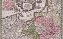
“Borussiae Regnum sub fortissimo Tutamine et justissimo Regimine Serenissimi ac Potentissimi Princips Friderici Wilhelm” from 'Atlas Novus.Tabulae Geographicae’, by Matthaus Seutter the elder (1678-1757), 1728.
The map includes Prussia, Pomerania, Polonica, Hockerlandia, Pomesania, Warmiaermelandia, Natanglensis, Galindia, Nandrovia, Sclavonia, and the Baltic Sea. The very large and elaborate cartouche includes 2 coats of arms, a crown, allegorical symbols, angels and cherubs, soldiers, with a portrait of Fredrich Wilheim in the center. A sea battle vignette is seen below the cartouche, a commercial port scene in the vignette on the right of the cartouche and a military dress review in the vignette to the left of the cartouche. There is a large inset of Neocomensis and Neufchatel in the upper left corner.