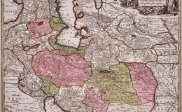
“Opulentissimi Regni Persiae juxta suas Provincias recentissima et accuratissima Designatio, Studio et sumtibus” from 'Atlas Novus.Tabulae Geographicae’, by Matthaus Seutter the elder (1678-1757), published in Augsburg, Germany in 1730.
The map extends from the Black Sea to Kashmir, divided into kingdoms. It includes a decorative title cartouche in the upper right, which depicts a Persian merchant with carpets and other items on the left and an astronomer with his instruments on the right, each by a large cornucopia signifying wealth. Manuscripts, maps, a globe and scientific instruments are shown in the lower portion of the cartouche.