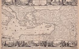
“Geographische Beschryvinghe Van de Wandeling der Apostelen ende De Reysen Pauli” (The Route of the Walking Tour of the Apostle Paul) by Nicolaes Visscher I (1618-1679), published in Amsterdam in 1669.
The map includes Italy, Sicily, Asia Minor, Babylon, Armenia, the Holy Land and the Red Sea. Nine vignettes illustrate events in the life of St. Paul the Apostle, particularly along his travels from Jerusalem to Rome where he died. Scenes include: the young Paul before his conversion, his baptism by Ananias, healing the paralytic, a shipwreck in Malta, Paul blinded on the road to Damascus, his escape from the city and an appearance before the Roman emperor Nero.