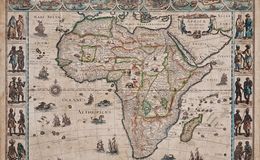
“Africae Nova Descriptio” from ‘Theatrum Orbis Terrarum, Sive Atlas Novis’, published in Amsterdam by Willem (Guillaume) Blaeu (1571-1638) in 1635.
This is one of the most decorative and popular of all the early maps of Africa. Nine African city maps and views are depicted in detailed vignettes along the top, including: Tanger (Tangiers), Ceuta (south of the Strait of Gibraltar in modern day Morocco), Alger (Algiers), Tunis, Alexandria, Alcair (an ancient city in Egypt along the Nile), Mozambique, S. Georgius dell Mina (?) and Canaria (Canary Islands). The map is decorated with nine sailing ships, seven in the Atlantic and two in the Indian Ocean; all flying Dutch flags. Flying fish, whales and sea monsters are seen in the oceans, while elephants, monkeys, lions, ostriches and camels are depicted wandering all over the continent. Ten decorative vignettes of costumed couples from various parts of Africa are present along the sides. The Nile is shown according to Ptolemy with its sources arising in Lake Zaire (unclear if this is modern day Lake Victoria of a factious body of water).