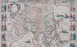
“Asia Noviter Delineata” from ‘Theatrum Orbis Terrarum, Sive Atlas Novis’, published in Amsterdam by Willem (Guillaume) Blaeu (1571-1638) in 1635.
Nine vignettes of city plans and maps across the top, including: Candy, Calecuth, Goa, Damasco (Damascus), Jerusalem, Ormus, Bantam, Aden and Macao) and ten vignettes along the sides depicting the dress of native people. The Great Wall of China is shown in detail. Korea is incorrectly shown as an island, although its northern border is very close to the mainland. Four sail ships, two sea monsters and a lion enhance the map.