Abu Ishaq Ibrahim b. Muhammad called al-Istakhri probably came from Istakhr, a city in the vicinity of ancient Persepolis. He is one of the four main tenth-century composers of a geographical text with a world map and, varying between the many copies, around 21 regional maps.
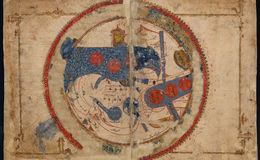
Since the maps are south-oriented, the Mediterranean appears on the right side of the map. It has an almost oval form whose western-most part is cut off by the inner circle marking the encompassing ocean into which its waters flow. Southwards, the Nile is represented by a rectangular strip. The broader and shorter blue rectangular strip to the North is the Black Sea.
On top of the blue, wavy water of the Mediterranean three red circles mark the islands Cyprus, Crete and Sicily. Only Sicily was under Muslim rule in the tenth century, when Istakhri compiled his work. In the thirteenth century, when this copy was produced in the Middle East, all three islands were ruled by Christian kings.
The Mediterranean is thus presented as a body of water that linked Muslim regions but was interspersed by insular domains of Christian powers.