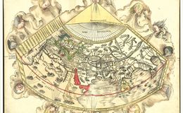
Striking example of Waldseemüller 's Ptolemaic world map, from the important 1513 Strasbourg edition of Ptolemy's Geographia. In his landmark catalog of world maps, Rodney Shirley called this map "one of the most attractive Ptolemaic maps ever produced” (Shirley, map 34).
The Strasbourg edition is widely considered the most important edition of Ptolemy's Geographia. The whirling wings surround the world as it was known to Ptolemy, the oikumene. The basic cartography of the map follows Ptolemy, although Waldseemüller does open up the Indian Ocean in the East and also eliminates the land to the south of the Indian Ocean which appeared in earlier maps. There is a very early use of longitude and latitude lines, along with notes on the climates in the left margin beyond the map.
Waldseemüller likely began work on the Geographia map in ca. 1505, when he was a professor of cosmography in St.-Dié. Waldseemüller worked on the Ptolemy with Matthias Ringmann, who collated the texts, while Waldseemüller compiled the maps. However, when their patron René II died in 1508, the St.-Dié Press closed down. Ringmann died in 1511. These events stalled the project and it was only in 1513 that the Ptolemy appeared, printed by Waldseemüller’s friend Johann Schott. Raremaps.com