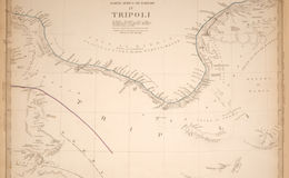
Africa. Published under the superintendence of the Society for the Diffusion of Useful Knowledge. Engraved by J. & C. Walker. London, published by Chapman & Hall 186 Strand, Septr. 1st 1839. (1844)
12.5 x 16 inches
This is one of four maps shown here as issued by the SDUK, as part of a two volume atlas issued by Chapman and Hall (this collection includes all of the African maps in the atlas, but not all digitized).
The SDUK, as the Society was known, produced inexpensive maps to encourage broad use in education. They were nevertheless rigorous and scientific in their approach, and as accurate as possible for the time period, which coincided with the most attempts at the interior exploration of the dark continent, as it was called. The maps in these two volumes were issued in parts over several years. This is the second edition, the first being by Baldwin and Cradock, with the maps issued in numbers and later bound as a set.
Incidentally, Baldwin and Cradock had earlier issued a rare U.S. atlas that is comprehensive and excellent.