The digital gallery
The digital gallery
<p>E189 – Africa Maps – 0300</p>
Image ID: 5156
Hide Dots
E189 – Africa Maps – 0300
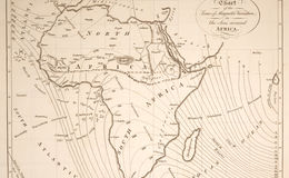
A small chart of the African continent in 1799 published in Bunney and Gold's Naval Chronicle. The chart depicts the magnetic variation in the South Atlantic Ocean and Indian Ocean surrounding Africa. Variation lines were measured by Captain Price.
Dots OFF
Dots ON
Exhibit Info
E189 – Africa Maps – 0300
E189 – Africa Maps – 0300
id?> title?> description?> --> -->
Featured Exhibits
Exhibit List
About Us
Tutorial
Login
Register