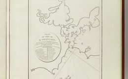
“This is the earliest obtainable map of San Francisco Bay. The map may seem a little hard to decipher by modern standards. It is oriented to the Northeast, the peninsula emerging from the right is the location of the modern urban center of modern Francisco, with the Golden Gate being the tiny entrance into he larger bay. The general form of San Pablo Bay, which leads into Suisun Bay is evident at the top of the map. The greater part of San Francisco Bay, extending towards the right side of the map is significantly truncated. The map identifies 21 place names, including Alcatraz, the Presidio, Merced, the Mission of San Francisco, and other landmarks, alphanumerically via a table integrated into the title cartouche...La Perouse did not personally survey the Bay, instead he most likely obtained the data for this map from the Spanish pilot Francisco Antonio Mourelle de la Rúa (1750-1820) in Manilla...La Perouse died tragically on a shipwreck near the Solomon Islands. His journals were shipped back to Europe from Australia before the shipwreck and posthumously published in 1797, along with an accompanying atlas volume, from which this map was drawn, Atlas du voyage de La Perouse.” geographicus.com