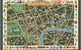
A terrestrial pictorial city map labelled The Daily Telegraph Picture Map of London, produced in 1950 by Geographia Ltd. 45.7 X 69.8 cm. It depicts the people, places of interest, boroughs, and streets of the city using bright colors, varied textual fonts, expanded images of famous buildings, and humorous images of subjects that are characteristic of famous places. The border shows vehicles and cartoonish people dressed in the style of the late 1940s. Mapping © Geographia Ltd. 1950, reproduced with kind permission of HarperCollins Publishers Ltd.
Rumsey