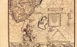
The 1507 map portrayed the oceans as a place of danger, or at least an unknown place, while the 1516 map portrayed the oceans as places that could be controlled by humans. This is especially evident in an image of King Manuel of Portugal riding a sea monster indicating Portugal's control of the route around Africa to India.
1
The 1507 map portrayed the oceans as a place of danger, or at least an unknown place, while the 1516 map portrayed the oceans as places that could be controlled by humans. This is especially evident in an image of King Manuel of Portugal riding a sea monster indicating Portugal's control of the route around Africa to India.


The 1507 map portrayed the oceans as a place of danger, or at least an unknown place, while the 1516 map portrayed the oceans as places that could be controlled by humans. This is especially evident in an image of King Manuel of Portugal riding a sea monster indicating Portugal's control of the route around Africa to India.
The 1507 map portrayed the oceans as a place of danger, or at least an unknown place, while the 1516 map portrayed the oceans as places that could be controlled by humans. This is especially evident in an image of King Manuel of Portugal riding a sea monster indicating Portugal's control of the route around Africa to India.