Ortelius used the Greek word Parergon to mean “Supplement”.
TRANSLATIONS:
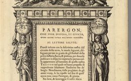
* Greek on top of the Plate: “Foolishness in the Eyes of God” (The meaning or implication of this statement is unknown).
* Central plate: “Dear Reader, after our description of the world, you have here the following maps I have designed for the benefit of those interested in old history, sacred and profane. I had decided to publish these in a separate book because they did not seem to be relevant to the maps in our “Theater” where I intended to show only present day locations. However, I gave in to my friends’ demands and have put them here as a Paragon. Greetings and be well disposed to our efforts.”
* Bottom: "Geography in the eyes of history”
At the top central is a serpent in front of books, flanked by primeval figures, one with a trident and the other with a rudder. Just below them are land clouds and winds. Similar to the Theatrum’s frontispiece, the central plate is flanked by a Sphere of the universe held up by a male figure and the world held up by a female figure.
From 1579 until 1595 a previous frontispiece was used. This woodblock print replaced the first frontispiece when the Parergon became a separate atlas with 49 maps in 1595. Five of these historical maps, Peregrinationis Diivi Paul…., Abraham Patriarchae Peregrinatio…,Typus Chorigraphicus , Geographia Sacra, and Senographia are in this presentation.These maps are also in various editions of Theatrum Orbis Terrarum atlases Ortelius drew and engraved the maps of the Parergon himself. These atlases were issued in two editions of 300 each.
Reference:
Van den Broecke, Krogt and Meurer , Edit. “Abraham Ortelius and the First Atlas ISBN# 9061943884
Curated text by Leonard Rothman December 2020.
Image from The Leonard and Juliet Rothman Holy Lands Map Collection at Stanford Libraries: https://searchworks.stanford.edu/view/dg325jp3937