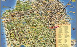
“A pictorial map by Don Bloodgood, who produced similar maps of other cities. The map is a reflection of the optimistic and giddy 1950’s, as well as Herb Caen’s fun-loving San Francisco’s.” Tom Paper
“Pictorial maps (also known as illustrated maps, panoramic maps, perspective maps, bird’s-eye view maps, and geopictorial maps) depict a given territory with a more artistic rather than technical style. It is a type of map in contrast to road map, atlas, or topographic map. The cartography can be a sophisticated 3-D perspective landscape or a simple map graphic enlivened with illustrations of buildings, people and animals. They can feature all sorts of varied topics like historical events, legendary figures or local agricultural products and cover anything from an entire continent to a college campus. Drawn by specialized artists and illustrators, pictorial maps are a rich, centuries-old tradition and a diverse art form that ranges from cartoon maps on restaurant placemats to treasured art prints in museums.” wikipedia.org
davidrumsey.com davidrumsey.com neatlinemaps.com