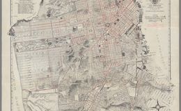
“Map of San Francisco on sheet 47x54, folded in paper covers 18x8. Copyrighted by August Chevalier, 1915. Shows the "Ground plan of the Panama-Pacific International Exposition. Relief shown by contours. Includes legend. Shows wards, city blocks, streets, railroads, bridges, tunnels, places of interest, important buildings are drawn in vignettes. Includes index to places of interest at the lower panel and index to theatres, railway depots and post offices at upper right. "Car lines" shown in red. Includes index and text on verso. See our other maps of San Francisco by Chevalier, from which this map is taken.” davidrumsey.com
“August Chevalier (fl. c. 1903 – 1932) was a San Francisco based lithographer active in the first decades of the 20th century. Chevalier is a remarkably elusive figure and little is known of his personal or professional life. He is best known for his large and magnificent topographical map of San Francisco boldly known as 'The Chevalier.' His few other maps also, almost exclusively, focus on San Francisco and the surrounding communities.” geographicus.com
wired.com


San Francisco Giants Ballpark
San Francisco Giants Ballpark