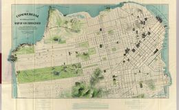
“A tourist map, pre-earthquake, with great detail of sights, structures, monuments and land contours. Was a fold-out map in a larger 32-page book on San Francisco.” Tom Paper “Important and rare pre-earth-quake San Francisco town plan. Covering from the "Sunset District" and the Blue Mountain, up to the Golden Gate and the northern shore of the city ("being filled") this is a very fine folding map, complete with its original guide. This colour lithographed plan has nice architectural detail for the key buildings. Including : Cliff House, the U.S. Mint, City Hall, the S.F. Examiner building, Wells Fargo, the Institute of Art and the huge Ferry Building.” swaen.com
davidrumsey.com