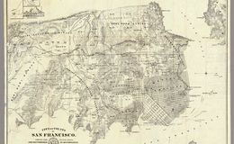
“Rare 1861 edition of this seminal map of San Francisco by San Mateo County surveyor V. Wackenreuder, lithographed by Britton & Rey, and published by Langley. This was one of the first maps to extend from Buri Buri Rancho (later South San Francisco) north across the Golden Gate to Marin County. This map features a lot of important topographic detail, documenting the peninsula in the midst of major changes to its landscape, especially the sand dunes of the Outside Lands and rivers and creeks which today no longer exist or have been significantly transformed. Equally important is the plotting of important early property owners and ranchos, along with infrastructure projects such as the path of the Spring Valley Water Works from Pilarcitos Creek to Laguna Honda reservoir and the San Francisco Water Works aqueduct to the still-standing reservoir on Russian Hill. Noe Valley at this time was called Horner's Addition, and a grid has been drawn here. Today the neighborhood is named after José de Jesús Noé, the last Mexican alcalde (mayor) of Yerba Buena, who owned what is now Noe Valley as part of his Rancho San Miguel. John Meirs Horner was a Mormon immigrant who bought the land from Noé a few years before, in 1854. At the top right are three insets of South Farallon Island. Overall, this map documents the city of San Francisco at a moment in which the city and its residents were locked in ongoing legal battles over land claims on two parallel levels: whether the land was part of the city or the U.S. federal government, and who owned private individual lots. davidrumsey.com
Loc.gov