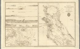
“Very rare and important chart of San Francisco Bay, the result of the first scientific mapping of the Bay. The chart had a wide influence upon later maps of the area. The chart, with copies and adaptations of it, served to the end of the Mexican period and formed the substantial basis of the earliest ones produced under the American regime. It was deficient only in the region beyond Carquinez Strait. The chart of the entrance contains additional hydrographic data pertinent to entering the port and reaching the chief places of anchorage. Accompanying the chart are elevation views depicting the approaches to the bay and the hazards to navigation.” davidrumsey.com


mount diable
mount diable