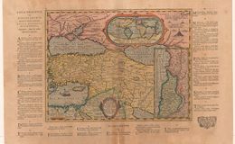
LUMEN HISTORIARUM per ORIENTUM illestrandus Biblijs sacris, Martyro-logio, et alijs multis Concinn. Fran.Hareio Antuerpiae. Translates as: "This Historical Enlightenment of the East, to illustrate the Holy Bible; the list of Martyrs and other matters.” This map was felt worthy and was included in the 1624 edition of Ortelius’ Theatrum Orbis Terrarum by his estate. List of location of the martyrs in the lands bordering the Eastern Mediterranean Sea. There is an inset world map at the top indicating the land of gold. There is also an expanded Holy Land map in the lower right. The dead sea is wrongly portrayed as sickled to the left when it should be straight north-south. Plate size 27.3x35.1 cm. Scale 1 :10,000,000. Number printed approximately 600. Map only in the 1624 Theatrum and the Parergon.
References:
1. Cartographica Neerlandica.com
2. van den Broecke, Marcel ORTELIUS ATLAS MAPS ISBN 9061943086
Curated text by Leonard Rothman December 2020.
Image from The Leonard and Juliet Rothman Holy Lands Map Collection at Stanford Libraries: https://searchworks.stanford.edu/view/11460821