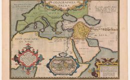
Title: Geographia Sacra, translated means ”Holy Geography.” Oriented with North on the top. Top right: ”From the geographical efforts of Abraham Ortelius, with an Imperial and Royal Brabant privilege for 10 years (1598).” Cartouche lower left “Because this map could not include the Ophira region, we have presented this world map separately. Of which we have noted disagreements in judgment of different writers. If anyone desires to know our true opinion about this matter, let he turn to our Geographical Treasure as we think, if he allows me, for additional information.” Upper left: ”The sea has been located in a spacious place, as if it were deep and large." Small world map caption: “This small map represents the locations of Ophyra (Gold)." Surrounding text: “The land and vastness of the world and those living on it belong to the Lord. Psalm 24." Bottom right legend: “Abraham Ortelius dedicates and recommends it therefore obediently and devotedly to the reverend and illustrious gentleman Guilelmus Grimbergen, the most dignified gentleman of Antwerp. From here they sailed on to Ophira (in the Persian Gulf), the river Hydaspis, which is considered to be the Phison and by others the Ganges, which this map cannot contain.” Plate Size: 35.6x 48.2cm. Scale: 1:15,000,000. Color Antwerp light pastels. Upper half of the map show ancient religious sites. Lower half indicates where there might be gold. No. printed 2625. Occurs in later Theatrums and the Parergon.
References:
1.Cartogaphica.com
2. van den Broecke , Marcel ORTELIUS ATLAS MAPS 9061943086
Curated text by Leonard Rothman December 2020.
Image from The Leonard and Juliet Rothman Holy Lands Map Collection at Stanford Libraries: https://searchworks.stanford.edu/view/11460910