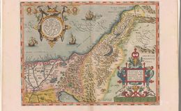
Translation in legend lower right: "New representation of Palestine or all of the Promised Land by Tilemann Stella from Siena with privilege.” Cartouche upper left is from Deuteronomy 8:7: “For the lord your God is bringing you into a good land, a land with rivers, streams and fountains issuing from plain and hill; a land of wheat and barley, of vines figs and pomegranates, a land of olive trees and Honey. There is no lack of food…”
The plate size is 13.25x18 in, with North on the top, drawn to scale of 1:1,500,000, engraved on copper by Franz Hogenburg. First issued in Ortilius’1570 first atlas THEATRUM ORBIS TERRARUM. This map is the 5th of 7 states. It has 3 ships in the sea. There were 7 known states varying by the number of ships and sea monsters. The decorative frames and scroll work is typical of Ortelius’ maps and the light pastel coloring is typical of Antwerp colorists. The map stretches from Phoenicia to the Nile Delta and from the Mediterranean Sea to and including Syria and Arabia. It also traces the route of the Israelites through the desert and the location of their 42 stops. This is one of the 2 keystone maps that were the basis of 17th century Holy Land Cartography. All 7 totaled approximately 6650 copies. The Dead Sea is incorrectly sickle shaped and should be straight north south. Map occurs only in the 1570 Theatrum and thereafter.
References:
1. Cartographica Neerlandica.com
2.Maps of the Holy Land Nebenzahl ISBN 0-89659-658-4
3.van den Broecke ORTELIUS ATLAS MAPS ISBN 9061943086
Curated text by Leonard Rothman December 2020
Image from The Leonard and Juliet Rothman Holy Lands Map Collection at Stanford Libraries: https://searchworks.stanford.edu/view/11460907