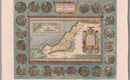
Abrahamo Ortelio Antverpiano auctore (in the rectangular legend top of the map with the map oriented to the North on top). Translation of title: Wanderings and the life of the Patriarch Abraham, by Abraham Ortelius from Antwerp. Banner along top and Bottom of the map area translates as: “Abraham, you must depart from your land and you must leave your relatives and come to the land which I will show you, and I will give you and your offspring after you the land to which you will wander, all the land of Canaan in eternal possession.” (Genesis 12 1-2) Cartouche middle right: “Dedicated as a sign of eternal friendship to Johannes Moflinius, a man of great humanity and excellent candidness, in many matters known to be noble.” Left middle of the sea: translates as ” With an Imperial, Royal and Belgian privilege for 10 years 1586.”
This unique map is presented as a tapestry and the Holy Land stretches from the Nile Delta to the Libano Mountains and headwaters of the Jordan River. An inset map in the Mediterranean Sea traces the route of Abraham. The map is surrounded by 22 keystone medallions by Maarten de Vos tracing the life of Abraham. The Dead Sea is wrongly sickled to the left instead of straight. The keystone medallion decoration, closely following the Bible, is the progenitor of Dutch decorative cartography. The copper plate was engraved by Franz Hogenberg. Plate size 32.5x45.7cm. Scale is 1:1,200,000. Edition 1595. Coloring is Antwerp light pastels with black back grounds in the medallions. Occurs in later Theatrums and the Parergon
References:
1. Cartographica Neerlandica .com
2. Book:Abraham Ortelius and the first Atlas ISBN 90 6194 388 4
3:Nebenzahl Maps of the Holy Land ISBN 0-89659-655-3 van den Broecke, Marcel ORTELIUS ATLAS MAPS ISBN 9061943086
Curated text by Leonard Rothman December 2020.
Image from The Leonard and Juliet Rothman Holy Lands Map Collection at Stanford Libraries: https://searchworks.stanford.edu/view/11460906