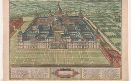
Translation of title: “View of all that has been built here in Escorial (to commemorate the martyr) Saint Laurentius.” Bottom on each side of the cartouche: a poem by Michael van der Hagen honoring Phillip 2nd King of Spain and Emperor of Belgium and Holland (See Cartographica .com for translation). Plate size 36.9x47.7. No scale. Coloring Antwerp light pastels. No. Printed 2525.
The building of Escorial took 21 years 1563-1584 and commemorates Phillip’s battle of San Quentin in Northern France. The structure contained a church, monastery, university and palace. (It was to be the “new” Jerusalem.) Philip was the head of the anti-reformation). Published in 1591, the plan was to be a personal gift from Ortelius to Phillip II (who appointed him to be his Royal Geographer. However, Ortelius wanted to make the presentation himself, but was never able to and he died in 1598. The presentation was later made by his estate to the king. No. printed 2750. This plan is included in later Theatrums and the Parergon.
References:
1.Cartographica Neerlandica.com
2.vandenBroecke, Marcel ORTELIUS ATLAS MAPS ISBN 9061943086
Curated text by Leonard Rothman December 2020.
Image from The Leonard and Juliet Rothman Holy Lands Map Collection at Stanford Libraries: https://searchworks.stanford.edu/view/11460911