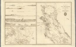
Early seafaring explorers from Spain, France and England sailed their ships along the West coast of America and often past the entrance to San Francisco Bay because it was shrouded in fog. Originally settled by Ohlone-speaking Yelamu tribe, San Francisco would be mapped by Spanish explorer Don Gaspar de Portolá in 1769 and later become a Spanish colony in 1776, with missions established throughout the area. Once the Bay had been properly explored and mapped out for navigation, Europeans began to settle within its boundaries and take advantage of the many natural resources they discovered. In 1821, Mexico gained independence from Spain and they renamed the small port town Yerba Buena. As seen in this detailed map, sailing into the Bay became easier with the aid of images like this one from 1833. It would not be until the end of the Mexican-American War in 1848 that the Bay and surrounding areas became part of the United States.
“Very rare and important chart of San Francisco Bay, the result of the first scientific mapping of the Bay. The chart had a wide influence upon later maps of the area. The chart, with copies and adaptations of it, served to the end of the Mexican period and formed the substantial basis of the earliest ones produced under the American regime. It was deficient only in the region beyond Carquinez Strait. The chart of the entrance contains additional hydrographic data pertinent to entering the port and reaching the chief places of anchorage. Accompanying the chart are elevation views depicting the approaches to the bay and the hazards to navigation.” davidrumsey.com


San Francisco Giants Ballpark
San Francisco Giants Ballpark