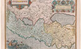
First published in 1584. Title in the Legend: "After Peter Lachsteen and Christian Schrott." The upper right ornate frame reveals vignettes of the birth, crucifixion and resurrection of Jesus. Sodom is noted to be on the edge of the Dead Sea. The upper right legend is perfectly balanced by a rendition of Jonah and the whale in the lower left of the map. The map is oriented with East on top. This map stretches from Galilee and terminates not at the end of the Dead Sea but at the beginning of the Lisan Peninsula. The land also extends from the Mediterranean Sea to Syria and Jordan. This East on top map is also a keystone for orienting Holy Land maps, that formed the basis of 17th century Holy Land Cartography. Approximately 4425 copies were made. Usual Antwerp light pastel coloring. Plate size 35x50 cm. Scale 1:1,500,000. First printed in 1579, this map is the 1624 edition. The total number printed was approximately 5425. This map occurs only in the Theatrum.
References:
1. Nebenzahl Maps of the Holy Land 1986 ISBN 0-89659-658-3
2. Cartographica Neerlandica.com
3. Van den Broecke ORTELIUS ATLAS MAPS ISBN 9061943086
Curated text by Leonard Rothman December 2020.
Image from The Leonard and Juliet Rothman Holy Lands Map Collection at Stanford Libraries: https://searchworks.stanford.edu/view/11460905