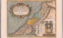
Translation of title: ”A chorographical map of the famous places in the kingdom of Judea and Israel, made with skill by Tillemann Stella of Siena.” Translation of cartouche in bottom right: “With an imperial and Belgian privilege for 10 years edited in this modest form, in 1586 by Abraham Ortelius.” Both the legend and the cartouche have Ortelius’ decorative frames and ornamentation. Oriented with North on the top. Stretches from the Nile Delta to Phoenicia and east to Syria and Arabia. The Mediterranean Sea, on middle left, contains for the first time a keystone list of symbols on a map; the translation of the list, from top down, is: 1)Significant metropolises and cities, 2) less significant places, 3) villages areas and mansions, 4) holy places and places of refuge, 5) cities of the Philistines that are 5 petty kingdoms, 6) and 7) special symbols for tribal places of Ephraim and of Simeon, because they are dispersed throughout the land. There is also a long statement between the legend and the western coast which translates into "Great Sea- Mediterranean Sea." This map of the kingdoms of Judah and Israel was first published in the Theatrum Orbis Terrarum in 1590 and then in the Parergon, Ortelius’ Geographical Historical atlas. The 12 tribes descended from Jacob are demarcated by dashed lines. The Dead Sea is incorrectly sickle shaped and should be straight north south. Coloring is typically Antwerp pale pastels. Plate size is 35x45cm. This map occurs in both later Theatrums and the Parergon. Scale is 1;1,200,000. Approximate number of copies is 3100.
References:
1. Cartographica Neerlandica.com
2. van den Broecke, Marcel ORTELIUS ATLAS MAPS ISBN 9061943086
Curated text by Leonard Rothman December 2020.
Image from The Leonard and Juliet Rothman Holy Lands Map Collection at Stanford Libraries: https://searchworks.stanford.edu/view/11460909