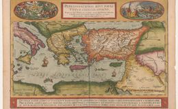
The legend center top: “A choriographical map of divine Paul’s wanderings based on the first history of the apostles of the new testament described by Saint Luke, on which are displayed for your eyes to behold, all geographical places.” The lower right: cum priuilegio Imp. et Regiae Maiestatis: ”with a privilege from his imperial and royal majesty.” Bottom left: Abraham Ortelius describbat 1579—“designed by Abraham Ortelius 1579.” Bottom Cartouche: Quonium Igitur….vt illi placaemus, “Since we know….to please him” from 2 Corinthians 5.
Medallion upper left shows the conversion of Saul on his way to Damascus. Blinded he falls from his horse and 2 men lead him to Damascus. The medallion in the upper right shows Paul and crew being shipwrecked on the coast of Malta Acts 2 39-44. They light a fire and when Paul throws more wood on the fire, a snake bites his hand and he shakes it off into the fire without being injured. The bystanders then think he is divine. There are no previous examples of these scenes and they may have been designed by Ortelius. The map shows the Eastern Mediterranean and the bordering countries. Three different states total approximately 5875 copies. Usual Antwerp light pastel coloring. This map occurs both in later Theatrums and the Parergon.
References:
1. Maps of the Holy Land Nebenzahl 1986 ISBN 658-3
2. New Testament 2Corinthians
3. Van den Broecke, Marcel ORTELIUS ATLAS MAPS ISBN 9061943086
Curated text by Leonard Rothman December 2020.
Image from The Leonard and Juliet Rothman Holy Lands Map Collection at Stanford Libraries: https://searchworks.stanford.edu/view/11460912