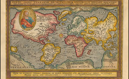
“Striking full color example of this fine early map of the World, which first appeared in the third of edition of Quad's Europae totius orbis terrarum, published by Johann Bussemacher. / Quad's map derives from Mercator's planispheric map of 1569, with the addition of the figure of Christ and a quote from Cicero at the bottom. South America includes the large western bulge, as shown in contemporary maps by Mercator and Ortelius. The mythical islands of Groclant, Thule, Frischlant and S. Brandam appear near Greenland. Large Terra Australis Incognita at the bottom of the map, predating the voyages of Le Maire and Schouten which identified the route around Cape Horn--with only the Straits of Magellan showing. / The cartography of Southeast Asia includes references to the mythical lands of Beach and Lucach, based upon Marco Polo, in the general vicinity of Australia, with a note crediting the Venetian for his travels in the region. No sign of the Korean Peninsula. Oddly shaped Japan. Unusual NW coast of America with clearly delineated NW passage and Northeast passage, the former being obscured by the image of Christ. Classic 16th Century cartographic representation of North America, dominated by the conjectural course of the St. Lawrence River reaching to Texas and the Great Plains. Quivira is a town on the west coast of North America. Many other early cartographic misprojections.” Raremaps.com
Barry Ruderman - raremaps.com