This handsome map, by William Faden, Geographer to the King, shows rich topographical and tactical detail , covering the actions of August -September 1776. Note, for example, the British ships landing the troops on Long Island at Gravesend Bay (lower center) and also the landings at Kepp’s (Kip’s) Bay, located at mid-Manhattan (present day 34th Street) at the East River. / Library of Congress, Geography and Map Division.
Library of Congress


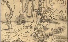
American sunk vessels here to deter the British from sailing this far, landing troops here and splitting the American forces.
American sunk vessels here to deter the British from sailing this far, landing troops here and splitting the American forces.
American sunk vessels here to deter the British from sailing this far, landing troops here and splitting the American forces.
American sunk vessels here to deter the British from sailing this far, landing troops here and splitting the American forces.