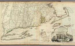
After 12 years of political struggle, the War of the American Revolution began in New England in early spring, 1775. As punishment for the Boston Tea Party (December, 1773), the British began to quarter Redcoat regiments in the town of Boston. This handsome map by Thomas Jeffreys, Geographer to the King, was printed in 1774 and shows southern New England and surrounding areas. In the right, there is a lovely cartouche depicting the landing of the Pilgrims at Plymouth Rock in 1620, and next to it is an inset of Boston Harbor. In upper right portion of the main map, there is Boston Harbor and just to the west are the villages of Lexington and Concord. Map published by Thomas Jefferys / Image courtesy of David Rumsey Collection © 2000 by Cartography Associates.
Rumsey


On Charlestown peninsula, on June 17, 1775, the bloody battle of Bunker Hill was fought.
https://en.wikipedia.org/wiki/Battle_of_Bunker_Hil...
On Charlestown peninsula, on June 17, 1775, the bloody battle of Bunker Hill was fought.
https://en.wikipedia.org/wiki/Battle_of_Bunker_Hil...
Here in Lexington on April 19, 1775, the shot "heard 'round the world" was fired. To the west is the town of Concord, where, later that day, the British expedition fought the American militia. The British column retreated to Boston and sustained heavy casualties from the harassing Americans. wikipedia / image
Here in Lexington on April 19, 1775, the shot "heard 'round the world" was fired. To the west is the town of Concord, where, later that day, the British expedition fought the American militia. The British column retreated to Boston and sustained heavy casualties from the harassing Americans. wikipedia / image
The Town of Concord
The Town of Concord
Cartouche depicting the landing of the Pilgrims at Plymouth in 1620 (MDCXX on rock)
https://en.wikipedia.org/wiki/Plymouth_Rock
Cartouche depicting the landing of the Pilgrims at Plymouth in 1620 (MDCXX on rock)
https://en.wikipedia.org/wiki/Plymouth_Rock