In 1777, William Faden published this topographical map depicting the capture of Fort Washington in upper Manhattan by combined British-Hessian forces on November 16, 1776. Washington had left the fort with its 2500 men and extensive cache of arms to defend itself, thinking the fort could hold out for weeks. The main American army meanwhile had crossed the Hudson and safely made it to New Jersey. Three columns of British-Hessian forces took the fort in just 5 hours. One column attacked from the south of the fort, a second attacked from the north, and a third made an amphibious landing at Harlem Creek. The loss of Fort Washington was the worst disaster of the war for Washington! / Image courtesy of Library of Congress, Geography and Map Division.


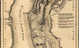
Fort Washington, an earthen structure, located on the heighest point in Manhattan. It was defended by 2500 men, but they were isolated and unsupported.
Fort Washington, an earthen structure, located on the heighest point in Manhattan. It was defended by 2500 men, but they were isolated and unsupported.