Image ID: 217
The Cornfield, where General George Washington met the panicked American troops running from Kip's Bay. He was unable to rally his men and his aides de camp led him back to Harlem Heights.
Kip's Bay, point of British attack on Sunday, September 15, 1776.
Trinity Church. The first church on this location was built in 1698 and destroyed as a part of much larger fire on September 20th, 1776, which just days after Washington's retreat from New York. The second church was built in 1790 and destroyed by heavy snow during the winter of 1838 to 1839. The third church was built in 1846 and stands there today.
Murray Mansion, where General Howe and his officers rested after their landing at Kip's Bay. The British troops halted nearby.
Putnam's Retreat. While the British troops halted near Murray Mansion, General Putnam led his force of 5,000 from New York City, up the West side of Manhattan, to safety in Harlem Heights.
Morris House, where General Washington had his headquarters in Harlem Heights from mid-September to mid-October, 1776.
Harlem Heights Battle. On Monday, September 16, 1776, the Americans probed the British lines on the south side of the Hollow Way. This developed into a full-scale battle with each side sending in reinforcements. Although the Americans pulled back to their defensive positions in Harlem Heights at the end of the day, they acquitted themselves well and made up for the rout the day before at Kip's Bay.
Fort Washington, an extensive earthen redoubt, intended to prevent Royal Navy ships from sailing up the Hudson.
Dots OFF
Dots ON


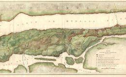
1878 Johnston Map of Manhattan in 1776
1776 Manhattan from 1878