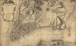
Also surveyed in 1767 by Lt. Ratzer, this map shows New York City in detail. It was a city of commerce, and for the late 18th Century it was a tolerant, bustling, and diverse city. It had already been said that New Yorkers spoke “very fast, very loud and all at once.” The North or Hudson River is shown to the left of the city and the East or South River to the right. Some streets including Wall Street and Broadway have kept their names through today. The rest of Manhattan Island remained largely wooded with farms and mansions spaced throughout. Across the East River, there is “Part of Long or Nassau Island,” today this is Brooklyn. Map surveyed by Bernard Ratzer. Published by Kitchin / Jefferys and Faden in 1776. / Image courtesy of Library of Congress, Geography and Map Division.
Library of Congress