Image ID: 211
In New York City, there was a population of 20,000 in summer 1776. The pin marks the intersection of Wall Street and Broadway.
View of New York harbor as seen from Governor's Island (see next dot)
Point on Governor's Island from which view at bottom of map is seen.
Kipp's Bay (shown as "Keps Bay" on map) is the point where the British invaded Manhattan on Sunday morning, September 15, 1776.
"Newtown Inlet" (Newtown Creek) where British forces formed prior to amphibious attack at Kip's Bay
Dots OFF
Dots ON


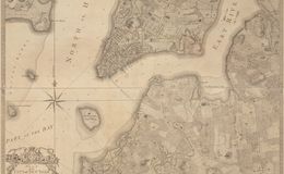
1776 City of New York - Bernard Ratzer
1767 New York City