Image ID: 210
While the British army in Boston prepared for the attack on Bunker Hill, Royal Navy ships fired upon the American positions.
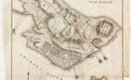
The British forces were ferried from Boston to Charlestown peninsula and formed here for the first attack on Bunker Hill.
At great cost of killed and wounded, the British ultimately captured the American fortification on their third attempt. The Americans retreated across Charlestown Neck.
Charlestown Neck, the retreat route of the Americans
The American earthworks, labeled "Warren's Redoubt," after citizen-soldier-physician Joseph Warren, who was killed at the battle.
Dots OFF
Dots ON


E40 - 1775 Breeds Hill
1775 Boston Bunker Hill