This charming map was based upon the observations of a British military engineer, Lt. Page, and was printed in 1775, after the battles at Lexington and Concord on April 19. As shown on the map, the British Army held Boston, then a town on a peninsula of 10,000 population, and the powerful Royal Navy controlled the harbor and rivers, but the Continental Army built fortifications (“Rebel Works”) to surround the British. Note hamlet of Charlestown across the river to north of Boston and "Dorchester Hill" to the south. Map author Thomas Hyde, 1775. / Image courtesy of Norman B. Leventhal Map & Education Center.
Leventhal


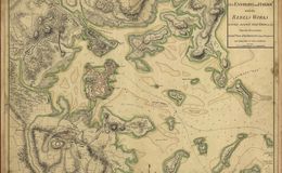
Thinking Dorchester Hill was not surmountable, the British left this position undefended. In March 1776, Washington surprised the British by taking and fortifying Dorchester Hill. From these heights American canon threatened the British in Boston and forced them to evacuate the town by ship on March 17, 1776. Today that is known in Boston as "Evacuation Day." wikipedia
Thinking Dorchester Hill was not surmountable, the British left this position undefended. In March 1776, Washington surprised the British by taking and fortifying Dorchester Hill. From these heights American canon threatened the British in Boston and forced them to evacuate the town by ship on March 17, 1776. Today that is known in Boston as "Evacuation Day." wikipedia