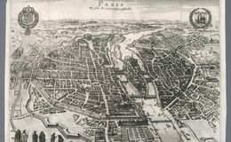
Parys, wie solche 1620, im Wessen gelanden (1620) Westward facing 1620 panoramic engraving details Paris during the reign King Louis XIII (1601-1610-1643) You can clearly see the cathedral of Nôtre Dame on Île de la Cité as well as windmills in the areas of Belleville and Montmartre to the north of the city (left side of the map). In the foreground, the Palais du Louvre sits centered with one side of its galleries completed along the river Seine. This wing of the palace leads to the now demolished Tuileries Palace that used to overlook the gardens depicted at the bottom of the map. Originally published in Frankfurt, this edition hails from the first Dutch language publication of French geography in the 1660s. / Image: David Rumsey Collection © 2000 by Cartography Associates
https://www.davidrumsey.com/luna/servlet/detail/RU...