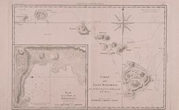
“Carte des Isles Sandwich”: A map created by Rigobert Bonne in Paris in 1787, shows the course of Cook’s ships through the islands that he called the Sandwich Islands (now know as Hawaii) in honor of Lord Sandwich (the inventor of the Sandwich) and the head of the British Admirality and a supporter of Cook’s 3rd voyage.
From Captain Cook’s third Voyage journal, he describes sailing along the coast of most of the islands but only made landfall on two of the islands: Kealakekua Bay on the big island of Hawaii (then called O’Whyhee), and at Waimea on the island of Kauai (then called Atooi).
This map includes a large inset of Karakakooa Bay on the big island, where Cook first landed and to which he later returned and was was killed by the Hawaiians.
The Richard & Leslie Breiman Collection.